What is remote sensing? What does it mean?
Remote sensing measures surface characteristics of vegetation, soil, water bodies or artificial surfaces from distance (without making physical contact). Different kind of sensors are used for remote sensing applications: field sensors (special case), airborne sensors and satellites. Earth Observation (EO) images are acquired with satellites to frequently cover the whole earth. Airborne EO data are normally used for special applications (e.g. aerial images, LIDAR) or to demonstrate the feasibility of a sensor concept as a testbed (e.g. for a future satellite mission).
In recent year's new platforms, called Unmanned Aerial Vehicles (UAV), are available for special applications (e.g. precision agriculture, quick overview at accidents, air pollution measurements).
Free software for satellite image processing, of satellite imagery of the Sentinel satellites for example, is provided by ESA.
Why remote sensing?
One of the main advantages of using remotely sensed data is the large-scale spatial information we can obtain with comparatively less effort. For example, a satellite image of Sentinel-2 covers 100 km x 100 km, or 10000 km2, from which you can extract information for agriculture, forestry, surface water bodies or urban planning. This information is recorded within seconds. If you want to gather this information using ground measurements, the processing time will take longer and also be more cost intensive. This type of treatment on a global scale is nearly impossible.
Take for example agricultural applications, Sentinel-2 can observe the vegetation development, phenology and plant health. In forestry, it is possible to distinguish coniferous and deciduous forests, and water stress and plant health (e.g. bark beetle attacks) can be monitored. By using remote sensing data planning procedures in urban areas are supported utilizing large-scale information also from the surrounding areas. One of the most important advantages of remote sensing data is the support for emergency response. For example, radar satellites (Sentinel-1) allow monitoring of flooded areas and can provide important information to rescue workers.

Electromagnetic Spectrum
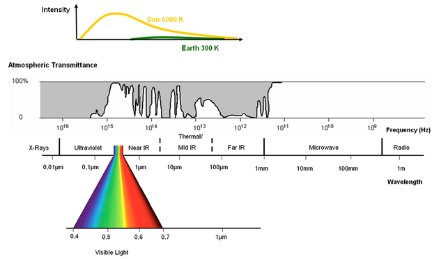
The light or visible light (VIS) we see is an electromagnetic wave emitted by the surface of the sun, which is at the same time the maximum emission region of the sun (there is a reason why evolution made our eyes sensitive in this spectral region). What we see is sunlight reflected from an object according to the characteristics of its surface. However, the range of this “light” is much wider than what we can see and provides additional information about our environment. EO sensors are able to “see” this “invisible” light and make it available to us.

Principle of Remote Sensing
In EO the most important medium to transmit information is electromagnetic radiation in the optical and microwave region, mainly detected and recorded by sensor systems onboard satellites and aircrafts. The measured signal is derived from the interaction of electromagnetic radiation with surface constituents, where it is absorbed, transmitted or reflected back up into space as a function of the bio-physical nature of the surface.
Resolutions in Remote Sensing - What does it mean?
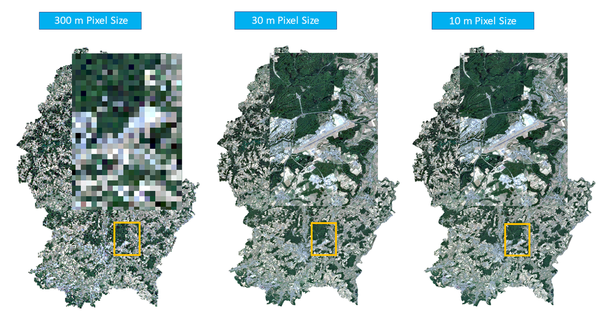
An EO system is characterized by the geometric, spectral, temporal and radiometric resolution. For global (e.g. weather) monitoring a relatively coarse resolution, but with high temporal resolution can be the best choice, e.g. images every 15 minutes for meteorological questions (pixel size > 1km).
For land cover monitoring a finer pixel size with lower temporal resolution is satisfactory (e.g. Landsat-8: 30m pixel size, 16 days revisit time or Sentinel-2 A/B with < 5 days revisit time in a two-satellite constellation with 10 - 20 m pixel size). Different applications need different kinds of resolution.
Geometric resolution of a remote sensing sensor describes the ability to detect objects on the surface. It is not necessarily the pixel size that you will get in an already processed satellite product. Sentinel-2 has different native geometric resolutions of 10, - 20 and 60 m (atmospheric bands) and will be later on processed for the whole image file to one geometric resolution / pixel size depending of the application. Particularly for airborne sensors, the geometric resolution can vary depending on the flight altitude of the aircraft when the image is acquired. If possible, the flight altitude is chosen to be close to the desired pixel size to avoid complex post-processing. The native geometric resolution is also called "ground sampling distance". For convenience, we will use the term geometric resolution to refer to the size of the pixels after post-processing.


Spectral resolution refers to the bands of a remote sensing sensor. It indicates the band properties of a sensor in terms of the available bands (number of bands), as well as the bandwidth of the bands. There are multispectral sensors with mostly broad spectral bands ("broadband"), meaning that each band covers a wide range of the electromagentic spectrum, as well as super- or hyperspectral sensors with narrowband characteristics, meaning a high number of spectral bands, with each band covering just a very small part of the electromagnetic spectrum (a bandwidth of a few nanometers).
The temporal resolution of a satellite in orbit is the revisit frequencyof a satellite to a particular location (ESA). Some examples:
Meteosat-11 (MSG-4): (geostationary): 15 minutes full disc imagery
MODIS: 1-2 days, 250m (2 bands), 500m (5 bands), 1000m (29 bands) GSD
Landsat-8: (sun-synchronous): 16 days on cloud-free conditions, 30 m pixel size
Sentinel-2 A/B (sun-synchronous): each 10 days, in constellation: 5 days on cloud-free conditions
An ESA video for Sentinel-2 shows this explanatory:


Radiometric resolution expresses the ability of an EO sensor to quantify the differences in reflectance intensity (or more simple: grey values) for each spectral band. With a higher radiometric resolution, the system will be capable to detect more grey values. The radiometric resolution is expressed in “bit”. For example:
1 bit = 21 grey values = 2 grey values
2 bit = 22 grey values = 4 grey values
4 bit = 24 grey values = 16 grey values
8 bit = 28 grey values = 256 grey values
10 bit = 210 grey values = 1024 grey values
12 bit = 212 grey values = 4096 grey values (e.g. Landsat-8, Sentinel-2 A/B)
For instance, Sentinel 2 A/B has a radiometric resolution of 12 bit, which means that Sentinel-2 can distinguish in each band 4096 reflectance intensities, a combination of 3 bands will result in a normal (or true) color image (RGB). The color is determined by the band combination: True color composites mean that the image will look like a normal photo, false color composites will have other band combinations, which may show the red edge or NIR bands and will have therefore an unusual colouring to our eyes.


True Color and False Color Images
Color Composites are just an visualization of different spectral bands. Normally we use a 3 band combination of Red (R) - Green (G) and Blue (B), which creates for us a familiar color impression, this is the True-Color-Composite. With EO data we have more than these 3 spectral bands meaning we have to assign the R-G-B channels of the screen to different band combinations. We could, for example, use the red channel of the screen to view a NIR band, the green channel to view the red band and the blue channel to view the green band of an EO system. This is called a False-Color-Composite, as we will see a complete different color scheme than we are familiar with. The resulting color impression will give direct information to the trained interpreter, e.g. about vegetation health.
RADAR
RADAR is the abbreviation for Radio Detection And Ranging, which is an active remote sensing system as it provides its own energy source. It is using electromagnetic radiation for the detection and location of reflecting objects such as aircrafts, ships, spacecrafts, vehicles, people and the natural environment. The analysis of the received signal allows to detect and locate the target under study but also to infer certain of its properties.

Image copyright: NASA, source: https://science.nasa.gov/ems/01_intro
Why RADAR in remote sensing?
Compared to the optical remote sensing, RADAR uses it's own power (or illumination) source and is therefore capable to made day / night observations and can also observe the earth's surface independent of the weather conditions. RADAR discriminates and depicts surfaces better than optical remote sensing, such as water bodies, waves, soil moisture, buildings and biomass. RADAR is an electromagnetic wave, the same as visible light. In contrast to optical remote sensing, RADAR bands are commonly characterized using the frequency and not the wavelength of the electromagnetic spectrum. The wavelength is inversly proportional to frequency. Depending on the frequency, RADAR can penetrate a few centimeters into the surface and the returned signal contains information on, for example, soil moisture. RADAR systems operate in different bands (frequency ranges), depending on the target and the mission. Here you can find an overview of the Radar bands.
Altimetry (e.g. on Sentinel-3)
Altimetry is a technique for measuring height. By measuring the time needed from a radar signal to travel from the radar antenna to the surface and back to the receiving antenna, the distance to the surface can be determined. For example, Sentinel-3 is equipped with an altimeter to measure the sea surface height (SSH) and wave height.
Radar Tutorials
https://www.ll.mit.edu/outreach/radar-introduction-radar-systems-online-course
https://www.radartutorial.eu/ (only in German)

